
The APRR network
APRR is wholly owned by Eiffarie, which is jointly owned by the Eiffage Group and Atlas Arteria.
As long-standing developers of the French territory, we operate and maintain the infrastructure and the network while committing ourselves to acting with respect for the environment.
Our 1,890-kilometre network connects French territories, supports economic development and promotes transport in all its forms by updating the travel experience. It extends from Paris to Mulhouse, from Toul to Lyon, from Annecy to Grenoble and from Bourges to Clermont-Ferrand.
The APRR network is structured along 4 main lines:
- Paris-Lyon (A5, A6, A31, A39)
- Burgundy-Northern Europe (A31, A36)
- Rhônalpin (A40, A42, A46)
- Central France (A77, A71, A714, A719).
Situated at the heart of Europe, the strategic position of the two networks fulfils the needs of transport companies, holidaymakers and commuters alike.
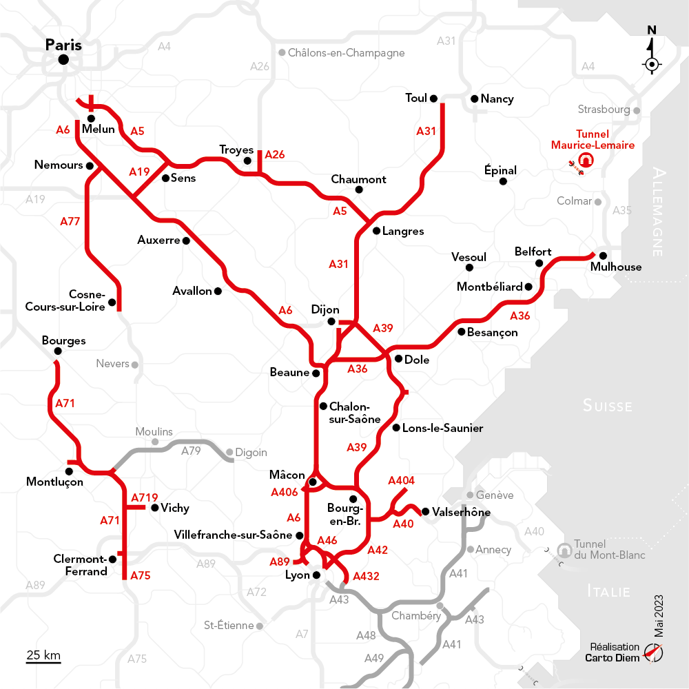
All the motorways of the APRR network
A5 Paris (La Francilienne) – Langres (A105 – ex-A5b: 10 kilometres): 247 km
A6 Paris (Saint-Germain/École) – Lyon (Limonest): 401 km
A19 Sens – Courtenay: 28 km A26
Troyes-Nord – Troyes-Est: 22 km
A31 Beaune – Toul (encompassing A311: 4 kilometers): 233 km
A36 Beaune – Mulhouse: 217 kilometers
A39 Dijon – Bourg-en-Bresse (including A391 5 kilometres): 150 km
A40 Mâcon – Bellegarde (Châtillon-en-Michaille): 104 kilometers
A404 Oyonnax spur: 21 km
A406 Mâcon southern bypass: 9 km
A42 Miribel – Pont-d’Ain: 49 km
A432 Les Échets – Saint-Laurent-de-Mure: 31 km
A46 Anse – Neyron: 26 km
A466 A6-A46 link: 5 km
A71 Bourges – Clermont-Ferrand (including A710 2 kilometres): 180 km
A75 Clermont-Ferrand-Est – Le Crest: 10 km
A714 Bretelle de Montluçon: 10 km
A719 Gannat – Vichy: 23 km
A77 Dordives – Cosne-sur-Loire: 101 km
A89 Limonest – La-Tour-de-Salvigny: 5 km
A79 Sazeret – Digoin: Maurice-Lemaire
Tunnel (including 4 km access section): 11 km
AREA, an Alpine subsidiary of APRR
The AREA network was born in the 70s with the ambition of creating a modern network of Alpine motorways. This movement naturally accompanied the rise of snow tourism and the region’s development.
Based in the Rhone region, AREA, a subsidiary of APRR, has operated a 409-kilometre network since 2006, consisting of the A41 between Chambéry and Grenoble, the A43 between Lyon and Modane, the A48 between Lyon and Grenoble, the A49 between Voreppe and Valence and the A51 between Claix and the Col du Fau.
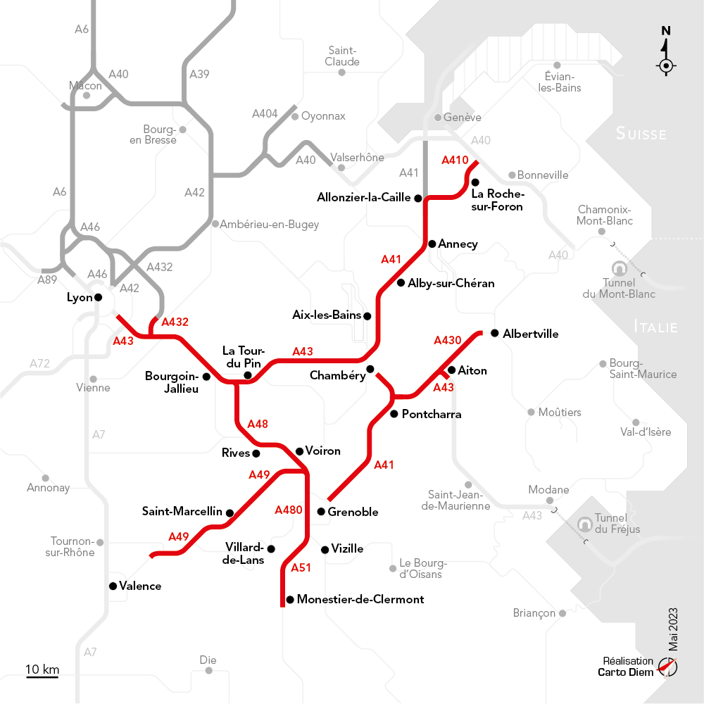
All the motorways of the AREA network
A41 Chambéry-Sud – Grenoble: 51 km
A41/A410 Chambéry-Nord – Annecy – Autoroute Blanche: 77 km
A41 (Liane) Annecy – Geneva: 19 km
A43/A430 Lyon – Chambéry – Albertville: 122 km
A432 Saint-Laurent-de-Mure – A43: 5 km
A48 Coiranne – Saint-Égrève: 51 km
A480 Saint-Égrève – Claix: 15 km
A49 Voreppe – Valence: 62 km
A51 Claix – Col du Fau: 26 km
APRR and AREA motorway
-
2 410kilometers
-
2emotorway group in France
-
2 818 M€in sales by 2022